Newsletter
10 June 2026
Welcome to the June 2026 Marine and Coastal Hub offshore wind farm environmental research update. This issue features progress on oceanographic, species and noise modelling for Bass Strait, data and information challenges, and a hub report on the exposure of pygmy blue whales to existing threats.
Orchestrating the gigabytes: Project 4.7 update
Hub Project 4.7 is developing methods and collating data required to conduct risk assessment for a suite of priority species that could be affected by offshore wind-farm development in Australia. This includes demonstrating the use of whole-of-ecosystem modelling and individual species modelling to estimate the population level impacts and cumulative risks of wind-farm development in the Bass Strait region.
Data collation and analysis
This phase of the project is almost complete and has involved negotiating and signing 13 data sharing agreements and collated data sets from 34 sources.
Data has been processed into model-ready format, including the removal of the same records held by different data portals. Across all priority species 2.6GB of observation data from 1979 to 2024 (including tracking, abundance, presence/absence and presence-only) has been collated and processed. An additional 97GB of observations of potential covariates (at monthly, 1km resolution) for the years 1993 to 2024 has been collated to develop design matrices for Species Distribution Models.
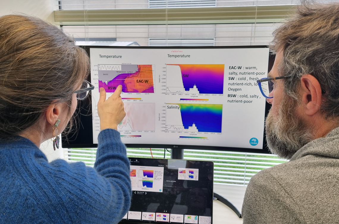
Oceanographic modelling
The new oceanographic and biogeochemical model (BASS) is complete and has been validated over the historical simulation period of 2017 to 2024. The model is being used to down-scale other model predictions for the future simulation period 2030 to 2040. The new Atlantis model is complete and being run over the historical simulation period.
Species modelling
Relative abundance and migration models have been completed for the curlew sandpiper, red knot and eastern curlew. Relative abundance and distribution models are being developed for the remainder of the priority species. Stochastic population dynamics models are ready to be run once mortality attributable to direct impact pathways has been quantified. The existing population dynamics model for shy albatross is being parameterised from additional data received from Tas NRE.
Noise modelling
The background noise model has been completed and is running for each of seven sound-scape classes to produce a background noise (shipping and wind) map across the assessment domain for Summer 2023. Commercial fishing by-catch statistics (per quarter, fishery and gear type) have been calculated for the years 2002 to 2025.
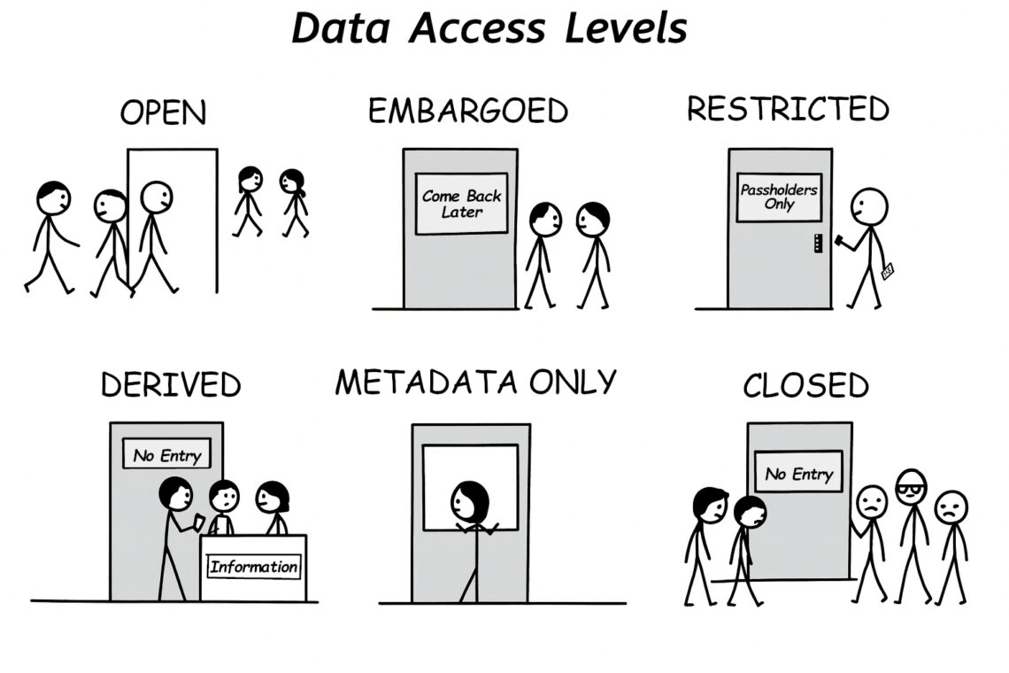
Many doors to data access
Environmental data sharing is a key topic across offshore wind energy projects. To support these conversations, this cartoon illustrates an important point: sharing information isn’t simply a choice between ‘open’ and ‘closed’. Rather, a spectrum of options enable smarter, more flexible ways to share data. By exploring these options, projects can improve efficiency, reduce costs and timelines, and build a stronger, shared understanding of the marine environment. The cartoon is available on the hub imagery catalogue. Please include the appropriate credit.
From data to information
The Australian Research Data Commons ORE Trusted Environmental Data and Information Supply Chains project is progressing a workflow for transforming environmental data into information products useful to industry and government. The project’s Shared Horizons workshop held in February (see the March update) has been a valuable part of this process.
Priority information needs identified by workshop participants included species distribution and abundance, collision-risk, underwater noise and benthic habitat mapping.
There was broad agreement that environmental information products must be driven by end-user requirements, supported by transparent governance arrangements, and underpinned by interoperable technical infrastructure and consistent data standards.
Barriers to data sharing included including intellectual property concerns, commercial sensitivities, legacy data issues, inconsistent standards, and the resourcing required to curate and manage data.
Pathways to overcoming these challenges included trusted repositories, clear data contribution processes, sustainable funding models, and improved data and information discoverability and access.
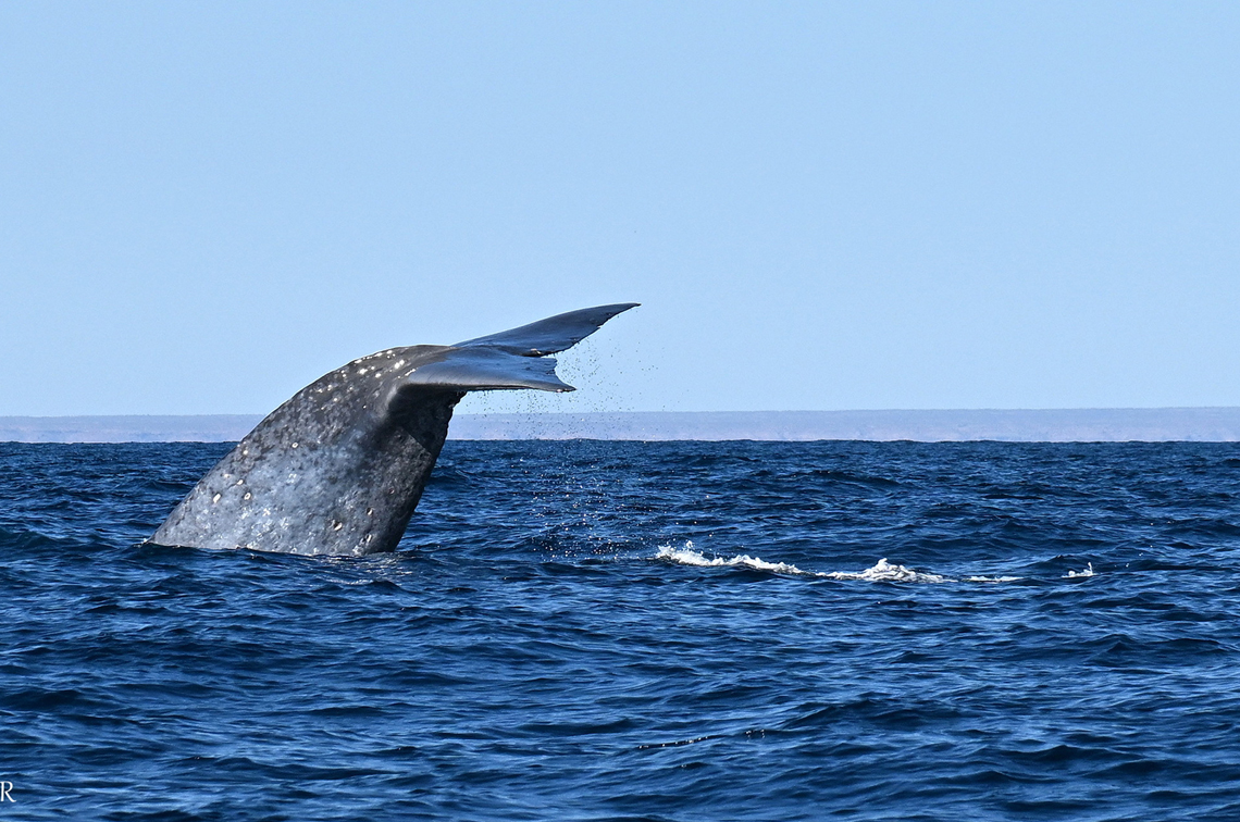
New mapping shows exposure of pygmy blue whales to existing threats is low, but knowledge gaps remain
A hub project led by the Australian Institute of Marine Science has mapped the known distribution, migration and foraging areas and potential threats for pygmy blue whales in Australia.
The project collated spatial datasets available for pygmy blue whales in Australian waters and created 10 by 10-kilometre resolution maps of relative distribution. The datasets included satellite telemetry; aerial, vessel and opportunistic surveys; catch records; and habitat suitability modelling. Foraging distribution was also mapped where behaviour data were available.
The updated distributions confirmed the importance of the Great South Australian Coastal Upwelling System, and areas of south-western and north-western Western Australia as important to foraging and migration. The monthly distributions, using tracking data only, confirmed a general route between feeding areas in temperate/subtropical latitudes to tropical waters. Most of the data was collected during the northern migration.
The limited southern migration data showed that some whales moved towards the Subtropical Convergence Zone. Although this area is outside Australian waters, it is significant to eastern Indian Ocean pygmy blue whale conservation.
Exposure to threats
Spatial datasets were collated for 10 existing pressures associated with potential threats to pygmy blue whales. The threats of vessel strike, underwater noise, pollution, entanglement, displacement and climate change were mapped to identify overlaps with pygmy blue whale distribution, as well as to understand the intensity and exposure of whales to ‘cumulative’ threats. Most of these threats were distributed throughout Australian waters (particularly underwater noise, pollution, vessel strike and climate change).
Exposure to these threats, and to cumulative threats, was calculated by overlapping the distribution of threats (individual and cumulative) and the updated distribution for pygmy whales (foraging and entire distribution). This was done to map a continuum between high exposure (high intensity of threats overlapping with high intensity of whales) and low exposure (low intensity of threats overlapping with low intensity of whales).
Australian and international researchers and managers were then consulted to help determine the probability of pygmy blue whales being exposed to threats in areas where their distribution overlapped each pressure. This contributed to calculating the probability of exposure of pygmy blue whales to each pressure. The final result showed a relatively low level of exposure to existing threats within the known pygmy blue whale distribution.
More data needed
While the estimated level of exposure to existing threats is considered relatively low, some caution is needed when using these results in decision-making. There is a lack of spatial data in some areas where whales have been detected acoustically, an absence of empirical data on the probability of interactions between whales and pressures, and gaps in data for where pygmy blue whales go and when.
Additional data collection is needed for:
- the southern migration (most existing knowledge is from the northern migration);
- presence in south-western Western Australia, the Great Australian Bight, Bass Strait and the Subtropical Convergence; and
- the Bass Strait and Gippsland regions, where all threats and the highest cumulative threat intensity were observed, and are likely to increase when the construction of the offshore renewable energy industry begins.
For all blue whale subspecies and genetic stocks, satellite telemetry, structured surveys, and analysis of existing passive acoustic monitoring data are needed to determine movement and distribution patterns. Existing spatial data need compiling to map probable occurrence, and behavioural and ecological studies are needed to understand potential effects of exposure to threats.
- The new mapping is available as spatial layers on Seamap Australia.
- See the Project 4.8 report and a more detailed story on the hub website.
Sign up for the update
Visit our home page and scroll down to join the mailing list for this update, and/or the quarterly Marine and Coastal Hub newsletter The Blue Drummer.
Related stories
Newsletter
Marine and Coastal Hub offshore wind farm environmental research update, March 2026
Newsletter
Marine and Coastal Hub offshore wind farm environmental research update, December 2025
Newsletter
Marine and Coastal Hub offshore wind farm environmental research update, September 2025
More stories