
Article
28 August 2026
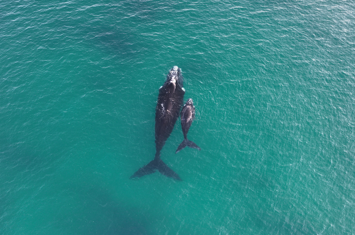
Satellite tagging and tracking of southern right whales has provided new insights into their movements, behaviour, and exposure to marine industries, highlighting potential risks, and opportunities for management intervention.
The four whales were tagged in June 2024 at Encounter Bay on South Australia’s Fleurieu Peninsula in hub research led by Flinders University. This re-emerging calving ground marks the approximate boundary of Australia’s eastern and western southern right whale populations. Understanding whether the whales head east or west from here is important to correctly defining and monitoring these populations.
The study tracked two unaccompanied adults and two cows that later gave birth. The tags transmitted for up to 198 days, recording individual movements exceeding 11,000 kilometres. The whales displayed transit, intermediate, and area-restricted search behaviours, generally travelling west or southwest and ranging between 31°–47°S and 96°–138°E. Their movements suggest all four whales belong to the western population.
The two mothers spent prolonged periods in known reproductive areas in South Australia and Western Australia, and at previously undocumented nursery areas along the South Australian coast. More than 19,700 dive events were recorded, revealing behavioural differences between mothers and unaccompanied adults. Mothers exhibited shallower dives and spent more time at the surface.
The satellite tracks also showed substantial overlap with multiple marine industries, identifying areas of heightened risk for this recovering species. This included nearshore regions of the Fleurieu, Yorke, and Eyre peninsulas in South Australia, and offshore areas near Bremer Bay and Albany in southern Western Australia.
Nine southern right whales, including the four satellite-tagged individuals, were photo-identified and added to the Encounter Bay Southern Right Whale Photo-identification catalogue.
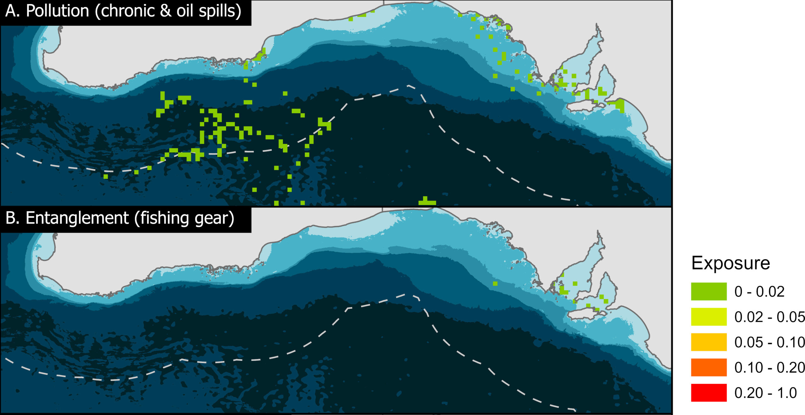 Risk exposure of southern right whales in southern Australia to (A) pollution and (B) entanglement. Risk exposure is characterised as the density of the threat layer multiplied by the number of whales occurring within the grid cell and is normalised between 0 (none) and 1 (maximum). Image: Flinders University
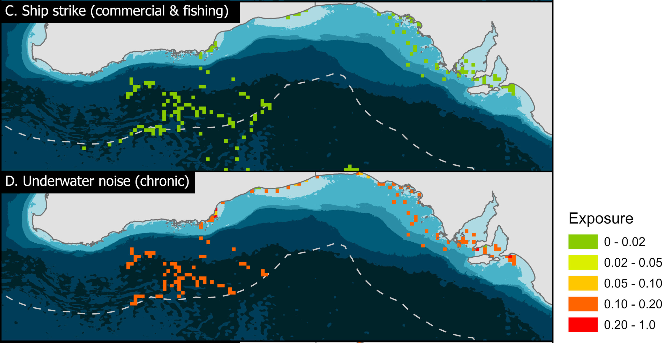 Risk exposure of southern right whales in southern Australia to (C) ship strike and (D) chronic underwater noise. Risk exposure is characterised as the density of the threat layer multiplied by the number of whales occurring within the grid cell and is normalised between 0 (none) and 1 (maximum). Image: Flinders University
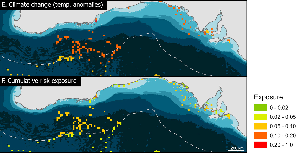 Risk exposure of southern right whales in southern Australia to (E) climate change, and (F) cumulative threats. Risk exposure is characterised as the density of the threat layer multiplied by the number of whales occurring within the grid cell and is normalised between 0 (none) and 1 (maximum). Image: Flinders University
Information for management
Results from this study support the implementation of the National Recovery Plan for the Southern Right Whale 2024. Key insights, including observed behavioural data, may inform future consideration of biologically important areas (BIA), a term used to identify critical habitat for conservation and risk mitigation measures.
The findings are also relevant to reducing the risk of vessel strike, and planning for offshore development in state and Commonwealth waters. The dive behaviour of cow-calf pairs is of particular interest because of their long surface intervals and shallow diving behaviour, which could increase the risk posed by vessel traffic at this critical life stage.
“Coastal movements are also informative, especially for pregnant and calving females, as they can reveal areas of importance not previously recognised for these whales that may need further protection,” says Claire Wouters, who is analysing the data as part of her PhD at Flinders University.
Tari (tag ID 261255), for example, spent significant time in the shallow waters of South Australia while pregnant and later with her young calf. She rested for multiple hours in nearly every shallow southeast-facing bay between Streaky Bay and Fowlers Bay, where she was first seen with her calf. This area is not currently classified as a BIA for reproduction in this species. Tari was also later identified at Head of Bight by the Australian Right Whale research team during a satellite tag transmission gap.
“Our findings suggest the current BIA boundaries may need reassessment in the future,” Ms Wouters says. “The identification of Tari by the Head of Bight team during a tag transmission failure also highlights the power of integrating different research methods to get the most comprehensive understanding of this population’s movements. When the tag resumed transmitting nearly four weeks later, it was revealed that she had travelled more than 1,000 km south toward the Subtropical Convergence.”
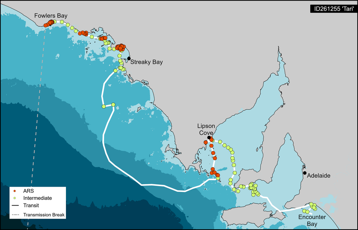
Project leader Professor Möller of Flinders University says that with the expansion of the population post-whaling, sites such as Streaky Bay, where this mother stayed resting for multiple days, need to be monitored as candidates for increased state government protection.
Inshore South Australian waters revealed some of the highest cumulative risk values across all four whale tracks, which has implications for coastal planning and vessel strike mitigation. Ship strike was a substantial risk identified for all four whales in Commonwealth waters. Potential management measures include slow zones for vessels or future designation as Whale Nursery Protection Areas.
“As more data on risk exposure becomes available, it will be crucial to further integrate risk assessments into marine planning, fisheries management and shipping regulations to minimise cumulative impacts on recovering right whale populations,” Professor Möller says. “Additionally, offshore development and infrastructure approvals need to have risk that is already present built into the approval process, to limit further cumulative risk to the species.”
The research team also emphasised the value of co-management with First Nations communities to encompass cultural knowledge, traditional stewardship, and community participation in conservation decision-making.
Tagging, sampling and collaboration
Recommendations to gain a more comprehensive and accurate understanding of southern right whale habitat use, movement patterns and exposure to threats include:
- satellite tagging of more individuals from both populations, encompassing different age classes, sexes, and reproductive states;
- integrating tagging with passive acoustic monitoring to detect whale presence and movement in key areas, particularly those with high entanglement risks;
- biopsy sampling and genomic analyses to study genetic health, population structure, and the level of genetic exchange between Australian and regional populations; and
- strengthening international collaborations such as the Southern Ocean Research Partnership, to share long-term data and understand risk exposure, especially to global environmental changes and increasing human impacts.
Related stories
Article
Satellite tracking provides a rare view of southern right whale movements beyond Encounter Bay, SA
Article
Catalogue updates and surveys sharpen the national view of southern right whale movements, habitats and populations
Article
‘Western’ southern right whale recovery remains stalled, 2025 survey shows
More stories