Article
4 September 2025
Scientists arrived at Nelson Bay north of Sydney in August with lights, cameras, and pilchards. Now they’re surveying life across the continental shelf of Hunter Marine Park, one of 60 marine parks managed by Parks Australia.
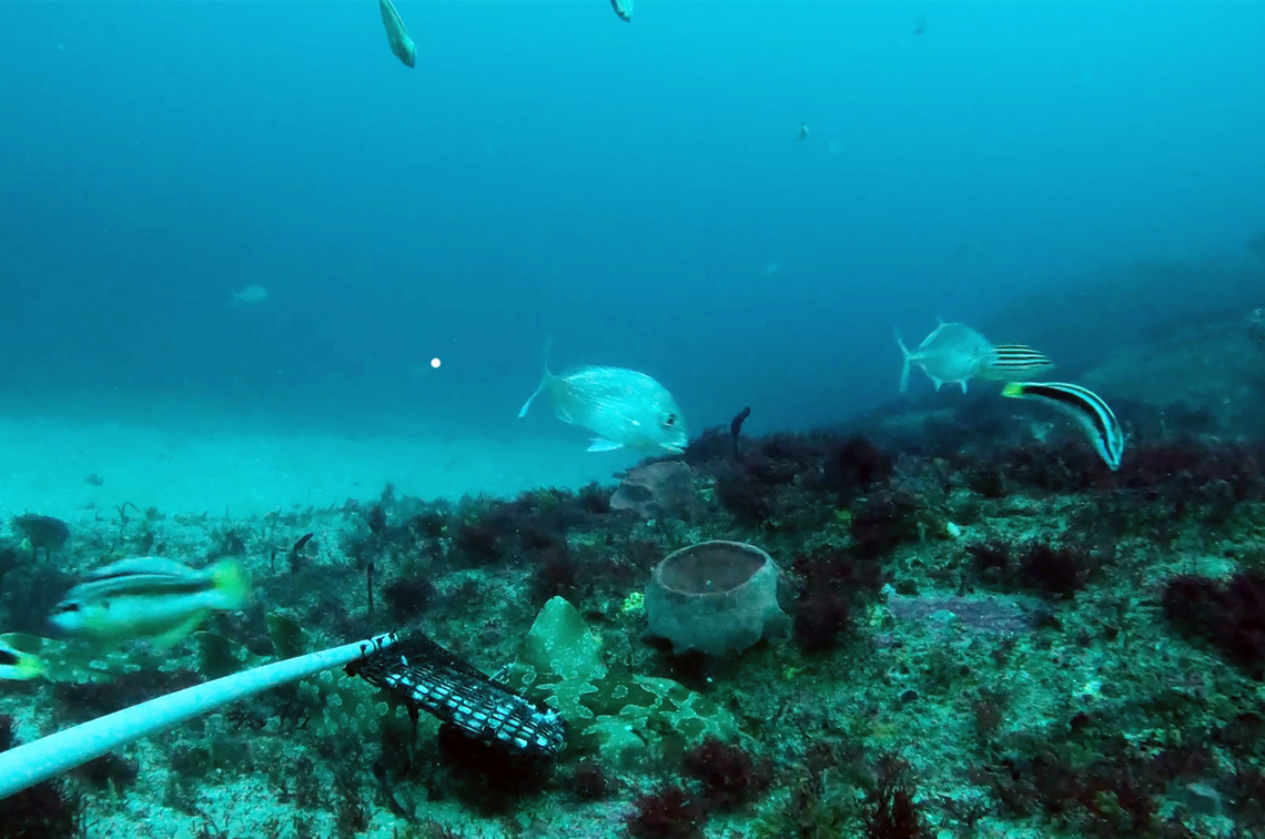
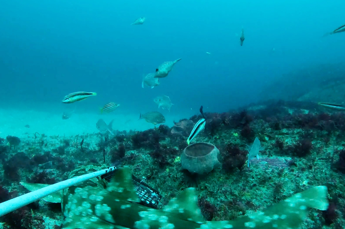
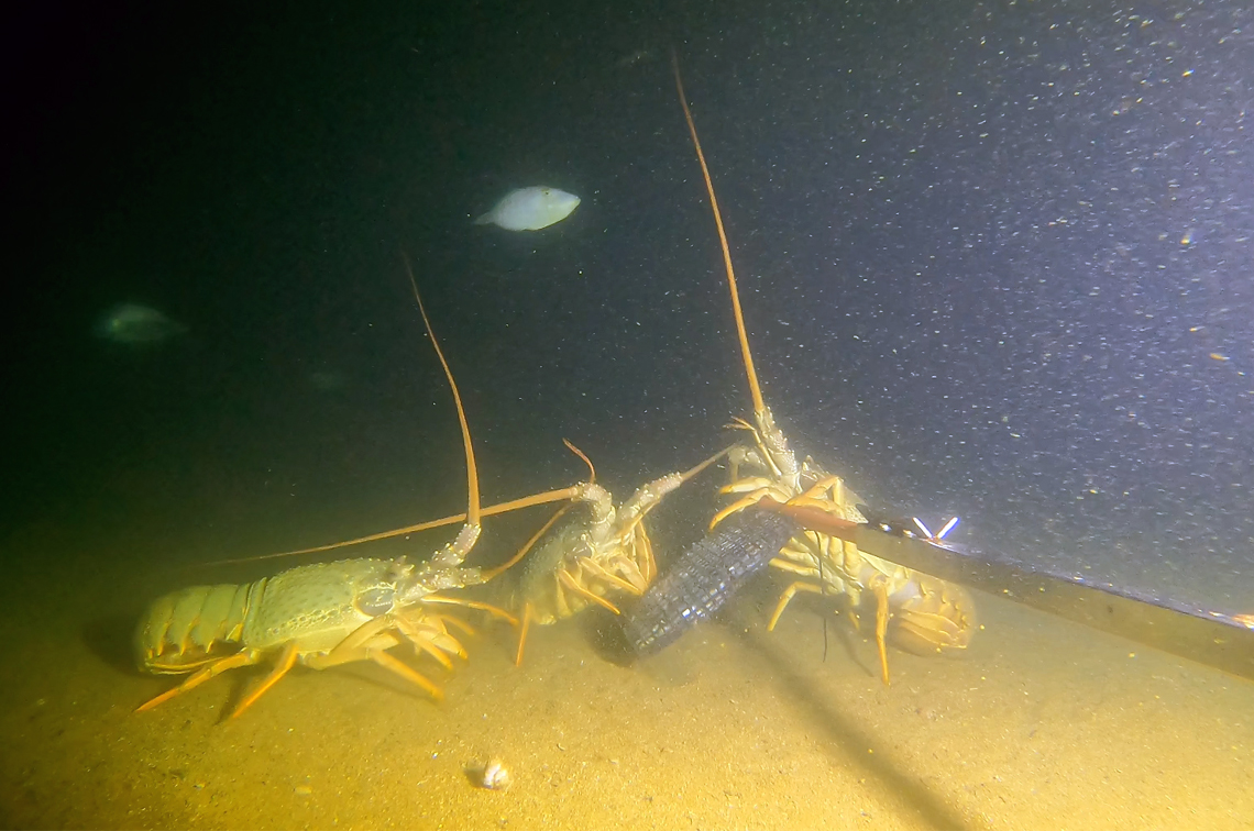
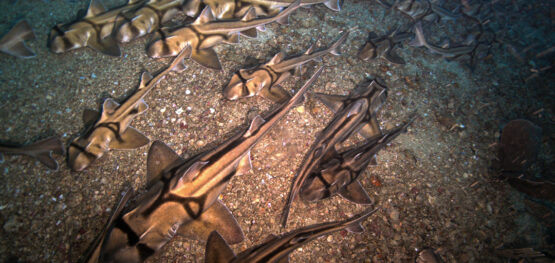
At depths below 50 metres, their cameras are capturing the wonderful world of fiddler rays, catsharks, Port Jackson sharks, hermit crabs, leatherjackets, lobsters, nannygai, bellowfish, serpent eels, sea whips, wobbegongs and snappers.
The three-week survey began on 12 August, and is working around the weather. It is led by Dr Jacquomo Monk of the Institute for Marine and Antarctic Studies (IMAS) at the University of Tasmania and supported with funding from the Australian Government under the National Environmental Science Program Marine and Coastal Hub.
The research is part of a wider project co-designed by the hub and Parks Australia that includes monitoring surveys in Beagle, South-west Corner, Geographe and Kimberley marine parks. The surveys contribute to Parks Australia’s mission to design and implement a national monitoring program for the Australian Marine Parks (AMPs).
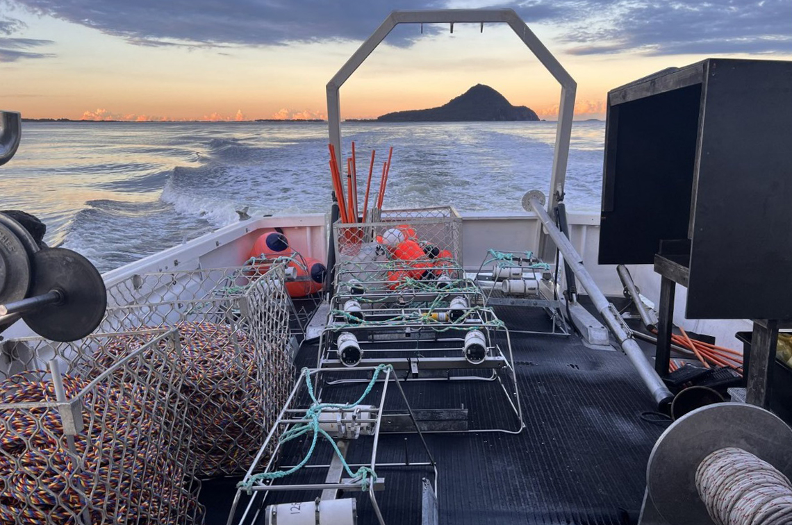
Dr Monk's team includes scientists and technicians from IMAS and the NSW Department of Primary Industries and Regional Development – Fisheries. They are using two types of camera systems to collect hundreds of hours of video documenting the park’s seafloor life and habitats.
The baited remote underwater stereo video, or stereo-BRUV, has a bait bag that is loaded with a kilogram of crushed pilchards and attached to a long pole. It is being lowered at 300 survey sites to provide critical information on the size and diversity of fishes within the Hunter Marine Park.
The second camera system, the remotely operated vehicle (ROV), is being ‘flown’ by a pilot onboard the vessel who can see and respond to the video feed in real time. The ROV will be deployed 50 times along 200-metre transects, providing new information on the seabed habitats and fishes that avoid the stereo-BRUVs.
First sweep of the shelf
“The imagery we collect will not only significantly improve our understanding of the biodiversity in the park but also the condition of its marine ecosystems,” Dr Monk says.
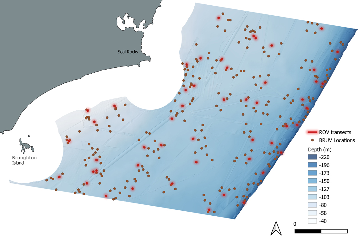
“Previous surveys by the hub and the NSW Department of Climate Change, Energy, the Environment and Water have mapped and sampled some of the park’s rocky reefs, primarily located in the mesophotic region of the parks inshore (western) boundary. This new survey will extend across an area of 2000 square kilometres – about one-third of the park’s total area – from depths of 50 to 220 metres.
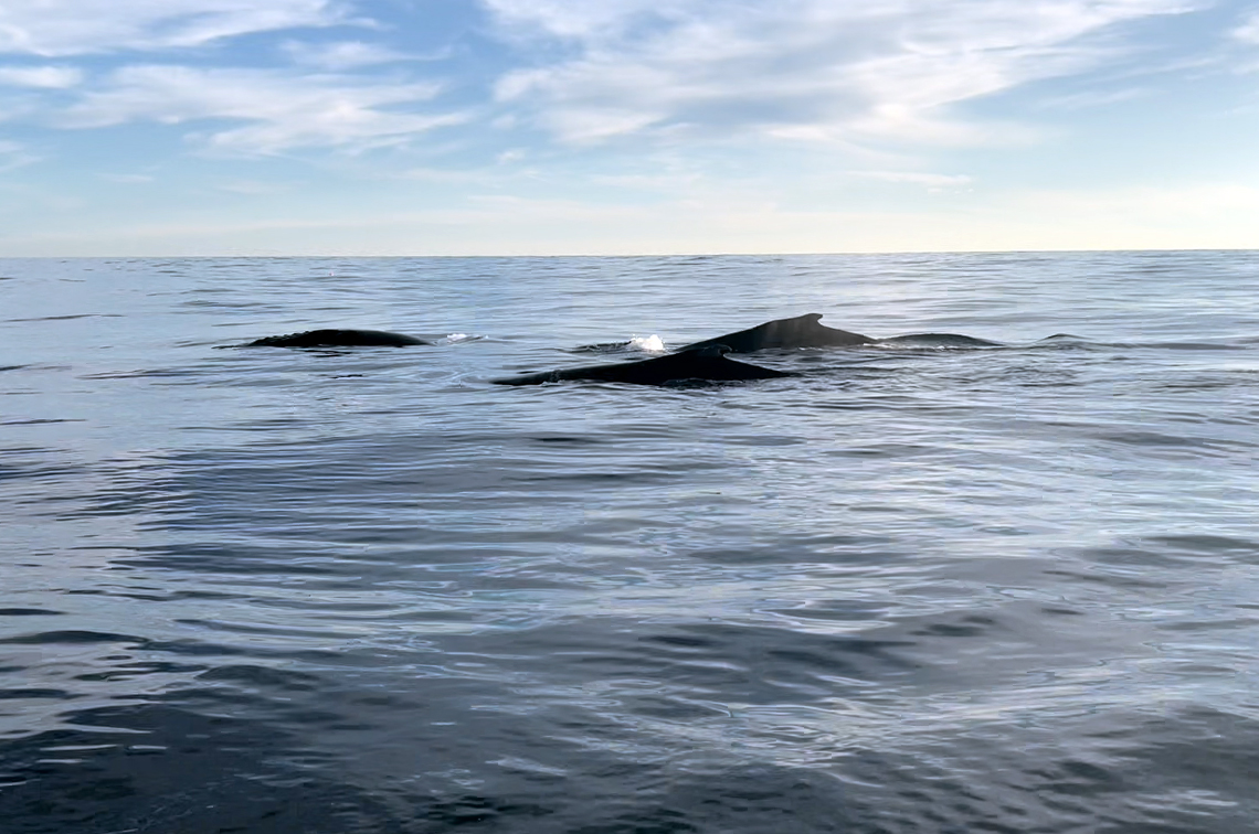
“A highlight so far has been seeing the whales coming to play; we’re careful not to put any equipment into the water when they are nearby.”
Hunter Marine Park is managed by Parks Australia and adjoins the Port Stephens–Great Lakes Marine Park, which is a State Marine Park managed by New South Wales Department of Primary Industries, Resources and Development.
It extends from ‘mesophotic' (mid-light) shelf waters out to the deep ocean and includes shelf rocky reefs and canyons. Its south-western edge is about 10 kilometres off Hawks Nest and its far north-eastern edge is about 105 km off Saltwater Beach.
The park is home to more than 110 fish species. The western section of the park, the focus area for this survey, supports significant commercial and recreational fishing. The deeper (eastern) section of the park is a Habitat Protection Zone, which protects the ocean floor habitat while allowing activities such as fishing in the water column.
Knowledge for park management
Information collected through the survey will be provided to Parks Australia to support the development of standardised monitoring approaches to inform evidence-based park management. They need the information to answer questions such as what are the important natural values in the park, and which species, locations and platforms might support effective monitoring to detect changes in the condition of marine ecosystems.
The survey findings will also contribute to the development of a standardised, national monitoring system to support the evaluation of management effectiveness across the Australian Marine Park (AMP) Networks, and the development of new network-level State of Marine Parks (StAMPs) reports to support an AMP management plan reviews.
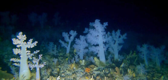
The survey team will be interested to see the deeper, mesophotic and ‘rariphotic' ecosystems at 30–200 m depths which host a diversity of sponges, octocorals, and sea whips.
The survey will follow standardised techniques outlined in the hub’s internationally endorsed best practice Field Manuals for Marine Sampling to Monitor Australian Waters. All imagery and associated annotations will be made publicly accessible via SQUIDLE+ and GlobalArchive, and explorable through Seamap Australia.
Further information
Explore Hunter Marine Park, including imagery from previous surveys, on Seamap Australia, Squidle+ and Global Archive.
Related stories
Media release
Scientists spot girls-only shark slumber party in Bass Strait’s Beagle Marine Park
Article
Not all reefs are rocky: new map sharpens focus on functional reefs across southern Australia
Newsletter
The Blue Drummer Marine and Coastal Hub newsletter, September 2025
More stories