Article
5 September 2025
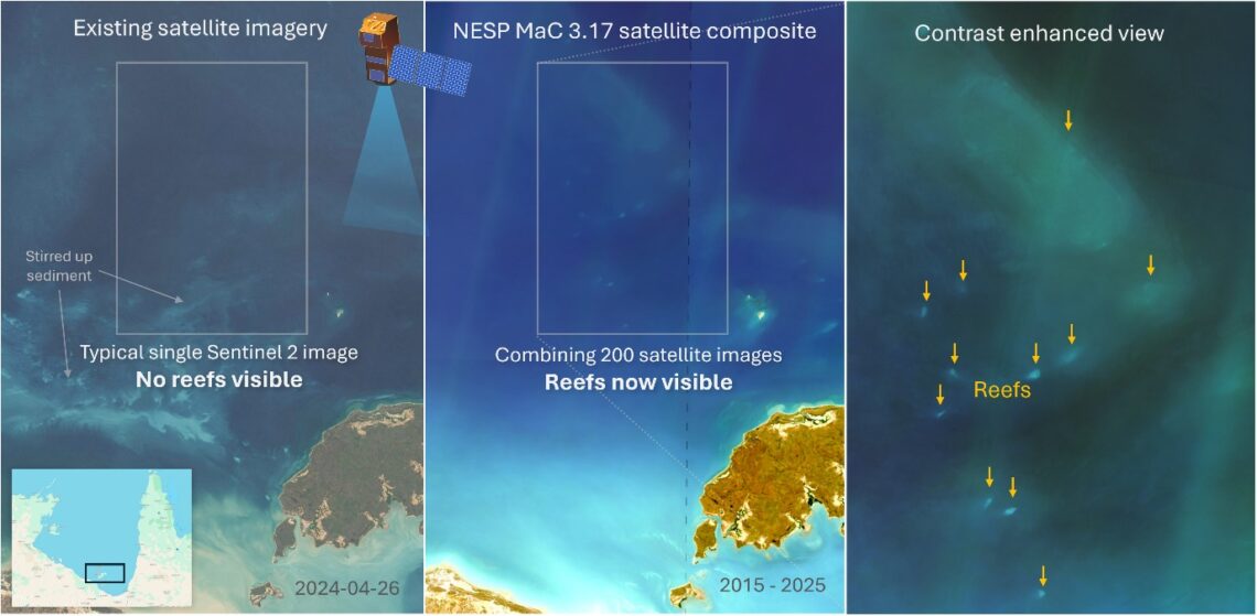
More than one thousand previously unmapped reefs have been identified as part of a Marine and Coastal Hub project, using improved satellite imaging and remote sensing methods.
In the remote, sediment-rich waters of northern Australia, these reefs had remained largely hidden. Absent from official maps, they have mostly been invisible to decision-makers. As such, despite providing habitat for a wide range of marine life, they are overlooked in conservation and development planning.
The hub project team, led by the Australian Institute of Marine Science (AIMS) and the University of Queensland, set out to solve this problem. They used comprehensive catalogue of satellite imagery, machine learning and existing field data to reveal extensive reef systems previously undetected by older techniques.
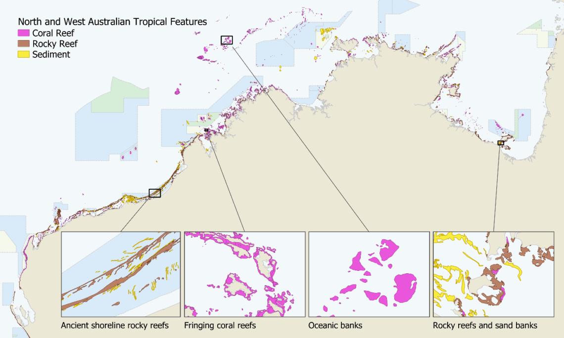
The project team put in 700 hours of manual mapping and classifying reef boundaries to create the first comprehensive view of coral reefs boundaries across northern Australia. This includes more than 4,000 coral reefs and 3,000 rocky reefs. The team also upgraded the shallow reef habitat mapping first developed as part of the Allen Coral Atlas. Improved satellite imagery, substantially more training data, and constraining the automated machine learning with the manual reef boundary mapping markedly increased delineation of habitats.
These new maps offer planners, Traditional Owners, and managers a much clearer view of reef and habitat locations.
“Having this level of detail means these important reef habitats can now be considered in environmental planning … It helps protect biodiversity and avoid unintended impacts.”
Dr Eric Lawrey, Project Leader
While the core study area was from Houtman Abrolhos in Western Australia through to western Cape York in Queensland, the team also rolled out the new imagery across the Great Barrier Reef to explore whether additional reefs could be detected. The timing was ideal, as a separate UQ project was remapping the outer reefs of the Great Barrier Reef. They adopted the new imagery, helping to identify hundreds of additional reefs and to remove false reefs. This revised dataset is now under review by the Great Barrier Reef Marine Park Authority.
Other project outputs include:
- a national high-resolution geospatial database of the Australian coastline at a scale of 1:50k;
- a georeferenced media library containing over 480 videos and 20 articles showcasing reef habitats across the north;
- a video tutorial on georeferencing YouTube videos for virtual fieldwork;
- a new raster dataset on tidal statistics across the Australian marine region; and
- tropical Australia Satellite Composite Imagery datasets showing the best cloud-free and clear-water imagery available for reef mapping.
The final datasets will be openly available through public data portals, including the eAtlas and AODN. By revealing what lies beneath northern Australia’s coastal waters, this project is supporting stronger protection for marine ecosystems that have long gone unnoticed.